Alamere Falls: Take 3

Dates hiked: 8/4/2012, 4/13/2013, and 4/12/2014
Distance: 8 miles out-and-back
Difficulty: easy to moderate (except for a difficult but short cliff-side climb at the end)
Best Season: Spring and Summer (spring for wildflowers and larger falls; summer for enjoying the lake)
Pro tip: There is one narrow stretch of about a quarter mile that has some poison oak growth. It’s not terribly overwhelming, but long pants and a jacket (or long sleeves) are recommended just in case.

Hi, friends! After a long hiatus, Hikology returns with our third journey to the beautiful Alamere Falls. (We’ve been on a handful of hikes in the past few months that I’ll catch up on in the future).

Our merry crew has been down this beautiful trail twice before, and it has never failed to disappoint us with its beautiful coastline scenery, wildflowers, and two kick-ass points of interest: Bass Lake, a secluded lake featuring a giant rope swing, and Alamere Falls, a tidal waterfall at the end of the trail, spilling straight into the ocean.

Here are a few shots (taken by Paul, of course) from our past trips:

The northern California coast, friends. Doesn’t get much better than this:
Coast

Fact: Jarrett is a fan of both hiking poles AND wildflowers!

Jarrett Wildflowers

It’s BECCA! In case you haven’t heard, Becca will be leaving the Bay Area this coming August to start her next adventure in London, pursuing a Masters in Public Administration at the London School of Economics. We’ll miss you, Bex!
Bex and Jars

The epic Bass Lake rope swing, featuring CHRIS!
Stosh Rope Swing


Because our first two trips were so fantastic, we knew we’d return again with those who hadn’t gotten to enjoy this awesome trail yet. Spearheaded by James, our sunset, moonlight hike to Alamere Falls had been planned about one month ago, based around a weekend with the fullest moon. We planned to hike the four miles out to Alamere Falls, enjoy dinner, wine, and a beautiful sunset, then hike back to the trailhead under light of the full moon and a sky full of stars. Unfortunately, Karl the Fog rudely inserted himself into our excursion and pretty much blocked out any direct solar and lunar luminescence. Not to worry! We had a lot of new people on the hike with us, and it was a fantastic time, and our headlamps guided us back to the trailhead unscathed.

Some shots from this past trip:

Dylan’s first trip to Alamere Falls!
Dylan Alamere

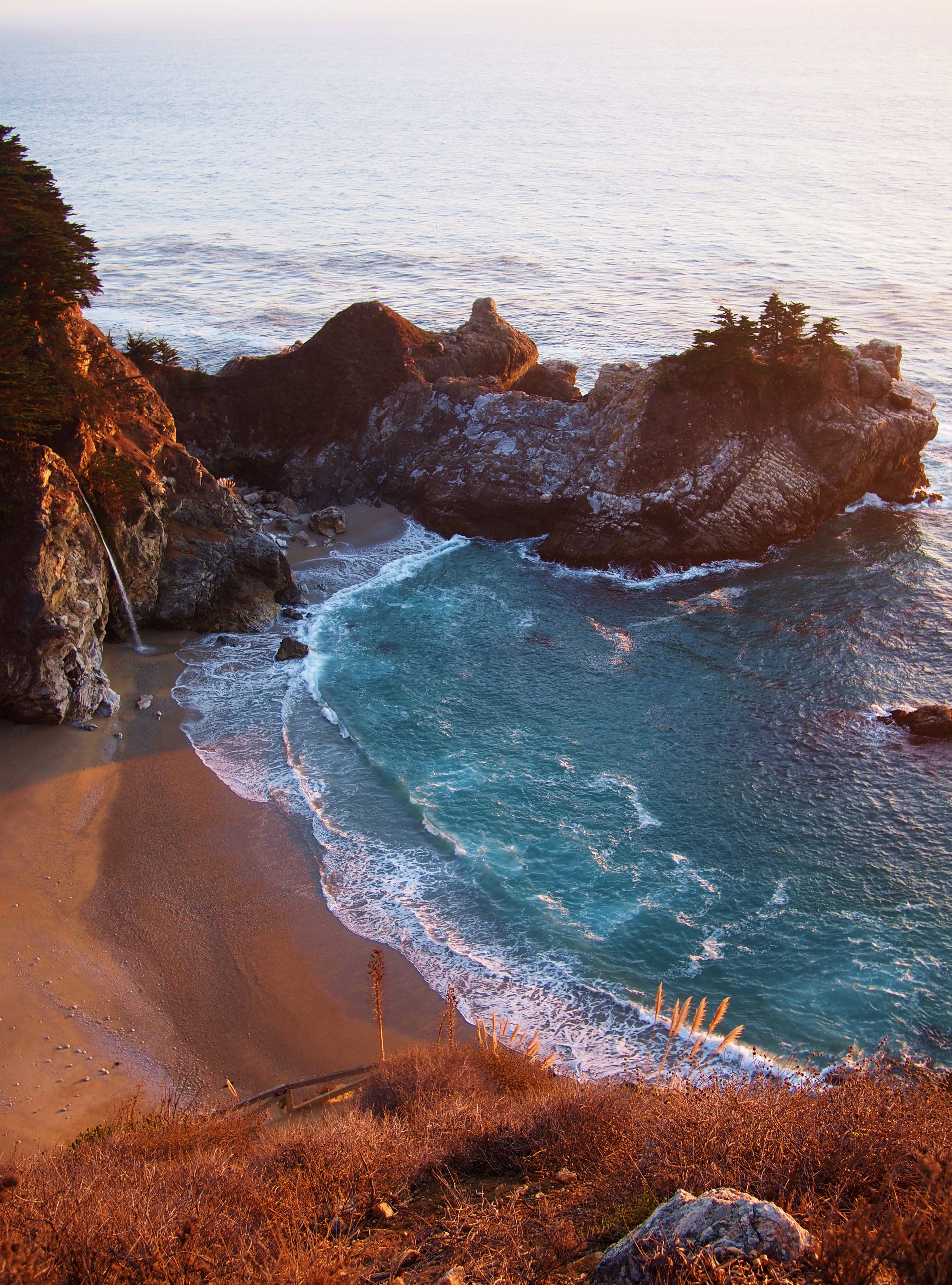
At the end of the trail, there are two steep cliff sides that require nimble feet and goat-like abilities to navigate. After the first cliffside, you see Upper Alamere falls. This is a long exposure taken by Paul — so gorgeous.
Upper Alamere

Cliff side number two! We did it!
Cliffside Climb

Becca and me, enjoying watching Jarrett’s many attempts to cross the tidal stream.
Bex and Tanya

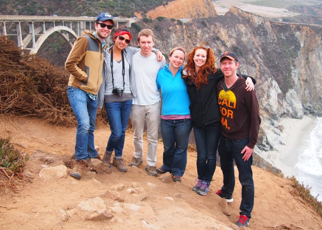
The crew! If I get the chance, I never fail to embarrass my friends by asking strangers to take a quick shot of us. They’re always embarrassed, but I contend that it’s worth it. Proof? Checkout the photo below! I’m going to frame it 😀
Hiking Club at Lower Alamere

After frolicking around the falls, we reconvened near upper Alamere to enjoy our dinner and wine. Needless to say, the sunset we were hoping to see was not at all visible, but it was fantastic having the entire beach to ourselves!

Alamere Dinner

Until next time, friends.

Big Sur Camping, Part Two: The One Where We Camped, Hiked, and Hot Spring’ed ‘Till 3 AM

After our productive morning (Part One) that included a hike to Pfeiffer Falls, Sarah, James, Jarrett and I headed back to camp where we found Paul and Lisa, who had just arrived moments earlier. Their arrival was extra exciting because Paul told me where Sarah and I had failed to get through to the hot springs reservation line, he had succeeded! I was ecstatic, and everyone else was an appropriate amount of excited.

While helping P&L set up, we enjoyed the classic PB&J for lunch and were able to really take-in and enjoy our awesome campsite, which was situated right on the Big Sur River. Overall the campgrounds were pretty crowded, with sites pretty close to each other, but we were lucky and had booked one of the larger sites right next to an opening to the river bank. We spent some quality time enjoying the river and skipping stones. Fact: James is a stone skipping artiste — I think I counted seven skips in one throw.

OLYMPUS DIGITAL CAMERA
Check out our digs right on the water! Doesn’t get much better than this…

Our afternoon hike took us about twenty minutes south on Highway 1 to Julia Pfeiffer Burns State Park where we couldn’t stop taking photos the second we stepped foot out of the car.

OLYMPUS DIGITAL CAMERA
Seriously!? This actually exists in California!

OLYMPUS DIGITAL CAMERA
In which I embarrass my friends again by blocking off the entire walkway for another awkward group photo — yay!

After admiring the coastline and the falls for quite some time, we started our actual hike onto the Ewoldsen Trail, a 4.5 mile loop that is known as the quintessential Big Sur hike. Unfortunately because of some landscaping and trail upkeep, half of the trail was closed of, but we were able to take the western half of the loop all the way up to the lookout point.

map_ewoldsen
Here’s a brief map of the trail — it’s only a 4.5 mile loop, but it was extra challenging because of the route we took. Because the eastern portion of the loop was closed, we did an out-and-back pathway on the western potion of the loop, which was a very steep uphill climb. Hiking up to the lookout point was pretty strenuous, and we ended up taking quite a few breaks along the way, but it was all worth it. The journey is documented below.

OLYMPUS DIGITAL CAMERA
A random tunnel that facilitated the production of some great monkey sounds.
OLYMPUS DIGITAL CAMERA
Lisa and Jarrett hustlin’
OLYMPUS DIGITAL CAMERA
Holy shrimp, we actually made it — phew!
OLYMPUS DIGITAL CAMERA
Check out that amazing view! It seriously felt like we were on top of the world after the crazy hike. The fog rolling in below also contributed to that effect.
OLYMPUS DIGITAL CAMERA
James and Sarah at the end of the trail. I love these two 🙂
OLYMPUS DIGITAL CAMERA
Heading home as the sun sets…

OLYMPUS DIGITAL CAMERA
This is sunset at McWay Falls, one of the three waterfalls in the US that empty into the ocean (the other two being Alamere Falls, which we’ve hiked to, and Waiulili Falls in Hawaii). The beach area you see to the left used to not exist — the entire inlet was filled with water, and the falls emptied directly into the ocean. However, a large landslide and resulting highway reconstruction project in 1984-1984 filled the little cove with enough sand to create the beach you see pictured.

With that last shot, the hiking portion of our trip came to a close. We were seriously exhausted as we headed back to camp, but we still had a significant part of the trip left — the hot springs!

Back at camp, we had leftover quesadillas and Sarah’s homemade lentil soup, which was fantastic. Camp was seriously cold; our area was tucked away under the cover of trees and foliage, so it never really warmed up during the day. We set up our campfire to stay warm, and then, of course, we s’more’d!

OLYMPUS DIGITAL CAMERA
So, instead of telling scary campfire stories, we decided to reveal our most embarrassing and hilarious childhood moments. I’ve known this gang for so long, but some of these tales were news to me. I’m still cracking up when I think about them.

We were killing time around the fire, waiting for the most anticipated part of the trip — the hot springs. As I mentioned earlier, Paul had managed to get through the busy phone lines that morning to make a reservation for our group at Esalen Natural Hot Springs.

The Esalen Institute is a beautiful retreat situated on the rugged Big Sur coastline that boasts natural hot springs. The hot springs are only open to the public from 1 am – 3 am, and during the off-season, you can only make same-day reservations. They also only accept about 20 people per night. Needless to say, we were extremely lucky to have snagged reservations.

After a short nap at the campsite, we woke up at midnight to sleepily make our way down the coast to the Institute. I won’t say too much about the springs except that the entire experience was magical. Seriously, if you are lucky enough to have the opportunity, you should have an experience at Esalen. Our tub was located right on the cliff side, so looking over the edge of the rocky basin, we could see and hear waves crashing onto the rocky coastline. It was surreal and magical to be in submerged the sulfuric water in the middle of the night under the clouds and on the coast with some of my closest friends. The experience was amazing and one that I will not soon forget.

OLYMPUS DIGITAL CAMERA
On our way home on Sunday we stopped in front of Bixby Bridge, which is one of the tallest, single-span, concrete bridges in the world and the most photographed on the Pacific Coast (thanks, Wiki).

And with that, I complete the long overdue, two-part Big Sur update. Happy holidays!

Big Sur Camping, Part One: The One With the Ewok

Now that I’ve put away the last of my camping gear and finally transitioned from old job to new, I can write about our awesome trip to Big Sur in October! Yes, it took me 1.5 months to finally put away the last camping item — a sleeping pad that had found a temporary home in my living room, not wanting to return to the depths of my storage unit. For full disclosure, the past 1.5 months have been incredibly busy: I was working full time while interviewing and job searching, Thanksgiving was on the timeline, Mitch (my future wedded partner and best friend) returned from a nine month deployment (see some awesome photos by the talented Katie Yuen here), and I adopted a rescue bunny from this amazing organization. Anyway, that is my list of mostly reasonable excuses, but without further ado: BIG SUR CAMPING!

Camping and I go way back. My adventurous dad instilled in me a love for nature and sleeping in tents, taking my sister and me every summer ever since I can remember. We’ve been to so many national parks, we’ve hiked a seemingly endless number of trail stairs, popped a squat on the most precarious of mountain ledges, seen the most beautifully clear, placid bodies of water (B.O.W.!), and gotten eaten alive by mosquitoes (they love me) countless times. Despite the ravenous bloodsuckers and the difficulties of nature calling in nature, all of these adventures opened my heart to the awesomeness of the great outdoors that I continue to enjoy with Hiking Club all the time! Thanks, Dad!

The first group (Jarrett, Sarah, James, and I) arrived to our campsite at Fernwood on Friday evening after sunset. Using our $2.67 headlamps (thanks, Costco), we enjoyed a dinner of quesadillas and set up camp pretty easily despite the darkness. We were pretty bushed (nature pun!!) from the work week, so we kept it pretty low-key that night around the fire and got to bed pretty early. Oh, and despite all my crazy lists and prep-work and countless email reminders to the crew, I forgot my pillow — classic. I was roughing it… with my down sleeping bag, sleeping pad, cozy tent, and iPhone. No pillow means roughing it, right?

The next morning, I woke up pretty early because we were trying to snag some very coveted hot springs reservations for that night. After over 100 phone calls, Sarah and I got a message saying they were all booked up. I was pretty bummed, but Jarrett and James were great at keeping my spirits up.

For breakfast, Sarah prepared her homemade instant oatmeal (she is awesome) for the crew. She is like the Martha Stewart of the great outdoors, minus the insider trading. After breakfast, we headed one mile south for a quick, three-mile hike to Pfeiffer Falls and Valley View. Since this post is already becoming quite long, I’ll just link you to a good trail description here.

OLYMPUS DIGITAL CAMERA
Breakfast at camp with some magical sunbeams.

OLYMPUS DIGITAL CAMERA
Oh, did I mention that Jarrett moonlights as an ewok?

OLYMPUS DIGITAL CAMERA
Sarah and me on our way up to the falls!

OLYMPUS DIGITAL CAMERA
Do not underestimate me: I won’t hesitate to embarrass everyone by forcing them to pose for an awkward group shot taken by a stranger. No regrets.

OLYMPUS DIGITAL CAMERA
Sarah and James enjoy the valley view.

Overall, the hike was short (three miles) yet challenging at some parts. The points of interest were a bit underwhelming, but it was a great way to get active early in the morning and productively use our time before Paul and Lisa arrived.

Part Two of our day is up next!

The Way, Way Back — Matt Davis / Steep Ravine / Dipsea Trail Loop

Date Hiked: 3/8/13
Distance: 7 mile loop
Difficulty: Moderate to Strenuous
Best Season: Spring and Fall for good, clear views and less crowded trails. Summer is fine too, but the views may be obscured by fog, and there will likely be more hiking traffic as well.

Hi, friends! This weekend really feels like the beginning of Fall. After our Indian Summer here in the Bay, things have started to cool down just a bit. Sitting in my big, green chair in my living room, I can see the leaves of “my” giant oak tree beginning their colorful transformation. It’s comfortable outside, but there’s a deliberate breeze that adds a definite crispness to the air. It’s perfect tea-drinking, sweater-wearing, scarf-knitting, puzzling, blogging weather. If there was any question about my grandma-status, it should now be answered.

Matt Davis - Apartment Tree
I love being able to see this big oak tree right outside my window.

This weekend, Hiking Club is taking a hiatus because of our busy schedules, so I’m taking this opportunity to catch up on all the hikes we completed before this little blog came into existence. Recently, I’ve been posting a lot about shorter hikes we’ve taken lately since we’ve been so busy, but when we first started regularly hiking, we were definitely taking on longer, more challenging, treks.

The first Hiking Club excursion took place quite a while ago on Saturday, March 8, 2013. I suggested the Matt Davis – Steep Ravine Loop at the the recommendation of a coworker, and the results were fabulous and really set the tone and excitement for all hikes to come.

This fabulous, 7 mile loop in Mt. Tamalpais State Park begins in the little town of Stinson Beach and consists of the Matt Davis, Steep Ravine, and Dipsea Trails. You’ll experience a wide variety of scenery, including waterfalls, creeks, bodies of water (Fact: I love bodies of water), rolling hills, forests and, on clear days, awesome views of San Francisco. It remains one of our favorite hikes and really got everyone excited about making hiking a regular part of our lives.

Trail Summary: 1. Begin on Belvedere Ave near Stinson Beach (close to the Stinson Beach fire station), starting on the Matt Davis Trail. Shortly thereafter, there’s an unsigned intersection where you’ll stay left to stay on Matt Davis. At 2.5 miles you’ll meet the Coastal Trail, but stay to the right and remain on Matt Davis. 2. After 1.7 more miles, you’ll reach a large intersection near a little parking lot. Cross the highway and the lot, and look for the Steep Ravine junction where you’ll continue on Steep Ravine. 3. After another 1.8 miles, the Steep Ravine intersects with the Dipsea Trail twice (check out the close-up below). The first time, stay on Steep Ravine, then at the second intersection, head right onto Dipsea, which will take you for about another mile until it reconnects with the Panoramic Highway. 4. From there, you can head back to the trail head or wherever you parked the car.

Matt Davis - Map
Matt Davis - Steep Ravine - Dipsea Intersection
Close up of the double intersection from Steep Ravine to Dipsea.

Matt Davis, master trail builder, worked on his segment of this loop in the 1920s after being commissioned to do so by the Tamalpais Conservation Club. We were honestly and pleasantly surprised by how varied it was — one moment, we were hiking through cool, moist (see side note below) forests alongside a creek with bridges and staircases, and the next we were in exposed grassland amongst rolling hills a la The Sound of Music.

Side note: Am I allowed to use the word “moist” as a descriptor? I’ve had some strong reactions to it when used in the past. In fact, we discussed this during the hike, and I discovered most people have an aversion to the term. This discussion also brought to light our group’s particular word-aversions. Paul isn’t particularly fond of “serene,” and Lisa, “cyber,” so naturally, Jarrett and I peppered every sentence with as many instances of each word as I could. We are such great friends!

To summarize, the hike was pretty fantastic with, as I mentioned, varied scenery and landscapes and offered a great workout. Because of this, I think we all became excited about making hiking a regular part of our weekend schedules, and Hiking Club, as we informally/affectionately call it, was born!

I wish I had more photos to share, but since this was the first Hiking Club excursion, there is a dearth of photos. I guess that just means we’ll get to hike it again.

Matt Davis - Lookout
Jarrett snagged this seemingly posed but actually candid shot of Lisa, Paul, and me looking over the water at SF.

Alright, now sending this serene hiking post into cyber-space!

Tilden Regional Park — Quarry/Big Springs/Seaview Trail

Date Hiked: 10/5/13
Distance: 3.5 miles
Difficulty: Easy
Best Season: Any time with a clear view

Can you smell it in the air? Hot apple cider, crispy leaves, and pumpkins — it’s October, and it’s my favorite month and time of the year. Halloween is right around the corner, followed by the feast of Thanksgiving, and then the festivities of the holiday season. October fills me with anticipation for the best time of the year and fills my little apartment with the comforting scent of pumpkin chocolate chip cookies, which we enjoyed on our Saturday jaunt to Tilden Regional Park.

Despite being a festive and fun season, life can get pretty hectic this time of the year — some of the crew are back in school, while others are working on important applications, studying for big exams, or just getting caught up in the hubbub of life. That’s why on Saturday, when some respite was much needed, we opted for a more abbreviated excursion to qualm our frayed nerves. Tilden Regional Park was the easy choice, since it is conveniently located in our alma mater’s back yard in the Berkeley Hills, and it did not disappoint.

Trail Summary: 1. Begin at the Quarry Trailhead, and hike on the Quarry Trail until reaching a four-way intersection with the Big Springs Trail. 2. Turn right and head up hill onto Big Springs for about three-quarters of a mile where you’ll come across a small parking lot. 3. Cross the lot and continue on Big Springs for another two thirds of a mile. 4. At the intersection with the Seaview/Skyline Trail, turn left and follow Seaview for a mile and a half to the view point, then back down to the Quarry Trailhead.

Tilden - Map

Our stroll began a bit past five o’ clock off Wildcat Canyon Road at the Quarry Trailhead where we saw this little guy:

OLYMPUS DIGITAL CAMERA
LIZARD!!

OLYMPUS DIGITAL CAMERA
Dusk is my favorite time of day — the lighting just creates the perfect, peaceful ambiance. The beginning of this loop takes you through quietly wooded patches where you can enjoy the faint scent of eucalyptus in the air and sunlight filtering through a tangle of branches and foliage.

Fact: The green pigment you see in leaves during spring and summer is called chlorophyll — it’s involved in the leaves’ production of food from water and sunlight. As the days shorten in the fall and there is not enough sunlight or water to produce food, the leaves rest and live off nutrients produced throughout the summer. At this point, the chlorophyll breaks down, and the leaves adorn their autumnal, red and golden garb. For the record, Lisa, in her intuitive ways, guessed this to be the reason for the fall change, and James, in his wise ways, confirmed this to be true. Yea, SCIENCE!

Continuing on the Quarry Trail, we reached the aforementioned four-way junction with the Big Springs Trail where we turned right and headed uphill (onto the Big Springs Trail).

OLYMPUS DIGITAL CAMERA
I always have to include a shot of the crew passionately discussing something! Directions, maybe?

Towards the end of the Big Springs Trail, the climb gets a bit steeper, but not by much. It’s well worth it when you reach the Seaview Trail junction because you’ll get some amazing views from up on the ridge.

OLYMPUS DIGITAL CAMERA
Can you really beat these sun kissed, grassy hills at dusk? This was our view of the San Pablo Dam Reservoir immediately after turning onto Seaview.

This portion of the trail immediately offers spectacular views to the East and, further along, to the West. Making our way along and trying to get to the peak of the hill before sunset, we reached a bench with what we thought was The Spot, but James, in his infinite wisdom, ushered us along a bit further where we found The Actual Spot.

Here, about twenty minutes before sunset, we found two benches along with a picnic table where we unloaded our snacks and sat back in awe of the perfect Bay Area sunset ahead of us.

Tilden - Venus and Sunset
Check this out: James pointed out Venus in the sky, and my iPhone surprisingly captured a fantastic shot of it! Venus appears brighter in the photo than it did in reality, and every time I look at this, I think it’s a mini-moon!

I think on every, single hike, we reflect upon how lucky we are to live here amongst amazing hikes and views and the best of friends.

Tilden - Group Sunset Panorama
Awww, friends4eva. Jarrett captured this scene with the iPhone panorama feature. From this point, we were able to see four of the five major Bay Area bridges, Alcatraz, and Angel Island.

The weather on Sunday couldn’t have been better. Fall in the Bay Area tends to be warmer than summer, and Saturday was a perfect example, gracing us with balmy evening breezes and clear, dry skies. We celebrated with seasonally appropriate oatmeal-pumpkin-chocolate chip cookies and a host of other munchies.

Tilden - Paul and Lisa (and Tanya)
Paul and Lisa (and me). I was going to crop myself out of this, but let’s be honest, this is my phantasy.

We finished the hike by continuing down the Seaview Trail, passing the intersection with Big Springs, and continuing back until reaching our starting point at the Quarry parking lot. During this last leg, the light was fading quickly, and there were swarms of mosquitoes out in full force, which meant… BATS! Bats emerged from their dark lairs, swooping around overhead in search of their next mosquito victim. Ew.

Fact: Paul hates bats.

Fact: Paul made it out alive and well, so I am able to leave you with this triumphant celebration:

Tilden - Paul Silhouette
Good night, Bay Area!!

Land’s End and the Batteries to Bluffs Trail

Date Hiked: 9/7/13
Distance: Land’s End half loop (1.5 miles); Batteries to Bluffs (.75 miles)
Difficulty: Easy
Best Season: Spring or Fall for clearer days and great views of the Golden Gate Bridge

I’m sure you’ve heard the old Mark Twain saying, “The coldest winter I ever spent was a summer in San Francisco.” While it’s not true that Twain asserted this, the assertion remains true — Summers in San Francisco are notoriously cold, foggy, and dreary. Because of this, warm, sunny days that begin in September, draw everyone out into fresh air, which is what happened the day we hiked the Land’s End trail.

We’d originally planned for a quick, three-mile walk in the Presidio, but we ended up starting at Land’s End and hiking all the way down to Marshall Beach via the Batteries to Bluffs Trail.

OLYMPUS DIGITAL CAMERA

Starting at Land’s End near The Cliff House and China Beach, we headed north towards the GGB. The trails were well groomed and pretty packed with people and amazingly clear views of the bridge, even through the spokes of this bicycle.

San Francisco was at its best, with all of our interesting, unique, beautiful people milling about, which made for great people watching! I couldn’t imagine living in a more unique, accepting, and wonderful place.

OLYMPUS DIGITAL CAMERA
China Beach crowds really show up on warm days!

Land’s End is a loop, and we hiked through the upper portion, but instead of turning back to complete the loop via the lower portion, we stopped at China Beach for a quick snack of lemon bars and for people watching. China Beach was, not surprisingly, packed with people that uncharacteristically warm day. What an amazing beach view of that bridge, though, yes?

From there, we left the Land’s End trail and walked through the San Francisco “suburbs” to connect with the Batteries to Bluffs trail. We passed Robin Williams’s abode, enjoyed the beautiful architecture, and I’m pretty sure I got my photo taken by someone’s security camera. There’s nothing like walking through palatial, security-ridden homes to really humble you; however, that only whetted our ambition. We all decided to someday buy houses here within walking distance of each other. Really. Seriously. Don’t believe us? Well, you’re probably right, but one can dream.

The Batteries to Bluffs trail begins along the San Francisco coast a little south of Baker Beach, continues past some artillery batteries, and provides breathtaking views of the Golden Gate Bridge along some really beautifully rocky sea cliffs.

OLYMPUS DIGITAL CAMERA
Fact: Baker Beach is known as San Francisco’s nude-ish/nudist beach! Here we are enjoying the view of the beach as well as some interesting “landscaping.”

OLYMPUS DIGITAL CAMERA
Check out this awesome shot Paul caught of one of the artillery batteries.

OLYMPUS DIGITAL CAMERA
Breathtaking view of the bridge from Marshall Beach on the Batteries to Bluffs trail. The trails here take you right onto the edge of serpentine cliffs where you’ll really feel part of the San Francisco landscape. Unlike Baker Beach, which can be bustling and busy, Marshall Beach provides a quieter, more contemplative atmosphere where you can really soak the the dramatic, rugged coastlines.

From there, we headed back to our starting point, making the little trip a quick, 4.5 mile, out-and-back hike and a great start to what was soon to be a warm San Francisco summer!

Angel Island — North Ridge / Sunset Trail Loop

Date Hiked: Sunday, 9/22/13
Distance: 4.3 miles
Difficulty: Easy to Moderate (mostly easy)
Best Season: Any, but try to go on a clear day for the best views

I know I’m behind by two weekends/hikes, but I had to document this past weekend’s first — it was fantastic!

After attending college in the Bay Area for four years and living as a (sort of) functioning adult here for two and a half years, I had never been to Angel Island. Why did I wait so long to visit? If you get the chance, don’t follow my footsteps — visit Angel Island as soon as you can because it is a fabulous little retreat with lots to do and fantastic, 360 degree views of the bay on a clear day. Angel Island is also sometimes thought of as the Ellis Island of the West Coast, so to speak, so there is a wealth of history, especially immigration history, to be found on the island.

To get to Angel Island, half of us took the ferry from Tiburon while the other half hailed from the San Francisco ferry. The round trip ticket from Tiburon costs $13.50, and the ferry ride lasted all of ten minutes. Quick and easy and free of sea-sickness. Paul was MIA this trip, so this post’s photos are my own unless otherwise noted. (Paul seriously missed out! Sorry, Paul, we’ll go again soon!).

OLYMPUS DIGITAL CAMERA

James, Sarah, Jarrett and I are ready to board the ferry from Tiburon.

OLYMPUS DIGITAL CAMERA

We rode in the back of the ferry and caught some amazing views of the GGB (that’s the Golden Gate Bridge!). On such a clear day, sailboats were out in full force, creating a truly idyllic scene on the Bay.

In researching which trails to traverse, we were recommended the five-mile Perimeter Loop, which circles the island; however, Sarah and James have a great book of Bay Area hikes (101 Great Hikes of the San Francisco Bay Area) that led us to choose the North Ridge Trail instead. What a fantastic decision!

OLYMPUS DIGITAL CAMERA

Hikers debating between the Perimeter Trail and the North Ridge Trail. The Perimeter Trail seems better suited for bicyclists and families with strollers, as it is almost entirely paved. We picked the North Ridge Trail because it is unpaved, has no bicyclists, fewer hikers, and reaches the summit of Mt. Livermore, the highest peak on the island.

The trail begins with a quick ascent up a set of stairs (about 150 steps?) then pretty much flattens out for the most part for the remainder of the hike. It crosses varied terrain, which keeps things interesting. You’ll hike through shady, cool wooded areas, grassy, sun-filled landscapes, and coastal cliffs with fabulous ocean views. I swear, rounding every corner, there’s an even better vista than the last spot.

OLYMPUS DIGITAL CAMERA
???????????????????????????????

A few scenic shots from the hike up that showcase the trail’s scenic variety. The third photo includes some recovering trees, the result of the 2008 fire that damaged nearly half of the island.

Angel Island - Bay Bridge

Group shot! Pictured in the background: San Francisco (to the right) and the new Bay Bridge, though you can most clearly see the half that wasn’t recently updated.

A few yards below Mt. Livermore’s peak, a few well-placed picnic tables offer great views of their own. We spent some time at the peak watching the Kiwis and the US battle it out during the America’s Cup with a perfect backdrop that included the GGB. You couldn’t ask for a better view!  After the race, we headed down a few yards to the tables for lunch where we were all introduced by Jarrett to Cookie Butter from Trader Joe’s. Personally, the jury’s still on out on this one for me, though everyone seems to be kooky for it (corny pun definitely intended).

OLYMPUS DIGITAL CAMERA

Lunchtime view near Mt. Livermore’s peak with Tiburon in the background.

Fact: Did you know the peak of Mt. Livermore is semi-artificial? In the 1950’s the US Army shaved off the top of the peak to facilitate the placement of the Nike Missile Site; however, the dirt was never discarded — just thrown down the hillside. In 2002, the peak was artificially recreated using the original dirt and native shrubbery.

After lunch and the great Cookie Butter debate, we began the quick descent back to the ferry landing.

OLYMPUS DIGITAL CAMERA

We spotted a few deer and this majestic hawk throughout the hike.

Angel Island - Bench
OLYMPUS DIGITAL CAMERA

Our descent included a break on this bench to enjoy the view. This pose was purported (by Lisa, photographed by Sarah) to be quite comfortable. What do you think?

After our super-sunny, super-scenic hike, we waited to catch the ferry back, enjoyed some live music drifting through the breeze from the little restaurant Cantina, and Irene and Chris devoured a well-deserved It’s-It, the San Francisco treat. Yep, Rice-a-Roni was wrong, it’s all about the It’s-Its. If you’re unsure what an It’s-It is, let me explain. This delectable goody consists of ice cream — vanilla, mint, chocolate, or cappuccino — sandwiched between two scrumptious oatmeal cookies all dipped in dark chocolate. It truly is the San Francisco treat — yum!

OLYMPUS DIGITAL CAMERA

Tuckered out trio heading back to Tiburon. Not photographed: our seal and dolphin friends.

Conclusion: This was one of the best hikes we’ve accomplished! We traveled by boat, soaked in some epic views, and surveyed an America’s Cup race from a mountain top all in the best company — couldn’t ask for a better Sunday afternoon!

Hikology and the Three Bears – Clarks Pool

This past weekend was Labor Day weekend, and a few of us decided to we were craving a quintessential, summer day of swimming, grilling, and summer fruit, especially because it’s been so hot lately. That’s pretty much all we had planned until about noon on Sunday, but somehow everything came together for a perfect summer getaway that included bridges, beers, and bears!

We met up with Kelsey and Dylan at their place in Davis and made last minute plans from there to head to Clarks Pool on the American River in Auburn, CA. We left armed with snacks and beers from Kelsey’s favorite Davis establishment: Nugget Market! (She’s actually been known to give tours of Nugget).

After parking at the trail head, there’s a short walk/hike of about .75 miles along the river to Clarks Pool. We debated as to whether this could truly be considered a Hiking Club excursion, since three of us were actually in flip-flops, and Paul forgot his camera. C’mon Paul, shirking responsibilities already!

The pool itself is more like a widened area of the river that’s dramatically located under the highest bridge in California, the Foresthill Bridge.

Foresthill Bridge

The Foresthill Bridge is the highest in California and the fourth highest in the US at 731 feet above the riverbed. Note that it’s been featured in timeless film classics like Vin Diesel’s “xXx.”

We easily found a relatively secluded area to post-up, and a few of us hopped right in while Jarrett began blowing up his floatie. Yep, he brought his floatie inner tube, and everyone was appropriately jealous. The riverbed is relatively shallow at parts, but for risk takers, there is a deeper area beneath a large rock where people were exercising their jumping skills.

As we were swimming downstream, Manal called us back because about 60 yards upstream, there were THREE BEARS, playing in the water. SO. COOL. The last time this group saw a bear in the wild was about three years ago in Yosemite.

Clarks Pool Bears

Manal was able to grab this shot the bear family! It was unexpected to see bears in that area, and to swim with them in the same river at such close proximity felt surreal.

Since two were much smaller than the third, we guessed the trio consisted of a mother bear with her two cubs. After some simple Google sleuthing, I found that the dry winter and warm summer were driving bears outside their normal territories in search for food. Good luck, bears!

The rest of the day involved me deviously splashing Paul as he attempted to slowly adjust to the water, then Dylan shoving me all the way in the river. It’s not really a water day until someone gets dunked, right?

Clarks Pool Gang

Manal snagged this shot of gang escaping the mid-day heat and Sarah taking advantage of the famous floatie.

Clarks Pool Gang 2

Sarah luckily got this shot that forever memorializes Dylan’s awesome, Euro-fabulous towel attire. If I’m not mistaken Fall Fashion Week begins today in New York. Dylan, are you trying to tell us this is what’s hot on the runways this season?

After returning to Davis, we fired up the grill and crafted some homemade hamburger patties, kebabs, sausages, and a strawberry crumble for dessert. We enjoyed the warm, Davis evening under the stars on an outdoor deck, and I was feeling pretty lucky.

I’ve known Kelsey and Jarrett since our Freshman year at Cal (Go Bears!) and met everyone else shortly thereafter; in fact, Kelsey was my roommate that year, and Jarrett lived just down the stairs from us. It’s pretty awesome to see how we’ve all gotten to know and grow with each other over the past eight years.

Overall, we had an absolutely perfect day that was hardly planned and just all came together perfectly in the end.

Hope everyone had a relaxing Labor Day weekend!

Castle Rock State Park Loop

Castle Rock State Park Loop

Date Hiked: 9/17/13
Distance: 6.5 miles
Difficulty: Easy to Moderate (learning more towards Moderate)
Best Season: Spring to early Summer in order to enjoy the falls and the greenery

Today (Aug. 18, 2013) is what I like to call a lazy Sunday. Those are the best, yes? I woke up sore from yesterday’s hike, enjoyed some breakfast, and am blogging from the little garden patio behind my building. I love days like this when I can just relax and really take the time to enjoy everything I’m lucky to have.

Yesterday, Hiking Club resumed after a month-long hiatus during the time Jarrett was exploring South America. Apparently, he’s the Hiking Club glue, so pretty much no hikes happened without him! We’d both heard really great things about the Castle Rock State Park Loop, which is in Los Gatos, CA, so we were excited to get started again with a great hike.  But because I’m directionally challenged, we got a later start than anticipated. For future reference: the main parking lot and Saratoga Gap Trailhead is located in the southeast corner of Castle Rock State Park on Highway 35/Skyline Blvd. It is not the first parking lot you encounter when approaching the park from the north. Who would think that? Not I…

The Castle Rock State Park Loop begins in the aforementioned parking lot on the Saratoga Gap Trail, which heads west for about 3 miles at which point it doubles back to become the Ridge Trail, which goes east back to the parking lot. There are detours throughout the loop where you can explore different points of interest like the Interactive Center, Goat Rock, and Castle Rock, and there are really beautiful vistas to enjoy along the way as well.

We first stopped at Castle Rock Falls, which was more like a teeny, tiny little trickle rather than falls (the result of a dry winter and the fact that we were hiking in late summer). Here, a wooden platform is placed atop a sheer rock face next to the top of the “falls.” I took a moment to hang out on the railing and watch the climbers below.

OLYMPUS DIGITAL CAMERA

Fact: Paul and Jarrett are afraid of heights; more specifically, they’re afraid of people who aren’t afraid of heights and publicly display their fearlessness. They did not enjoy my lackadaisical attitude towards the sheer drop below.

Fact: Major H/T to Paul, our unofficial historian. He has a great eye and knack for capturing the hilarious, beautiful, and striking moments of our trips. Most photos I’ll post will be courtesy of Paul. Thanks, Paul!

This hike had so many interesting points along the way, but I’ll just share some highlights. Towards the end of the loop, we found a crop of boulders that included a super cool cave we just had to explore. This involved climbing up a fallen tree trunk and through a tiny, little opening.

Castle Rock CaveDylan and I high-five our cave success — we made it!

OLYMPUS DIGITAL CAMERAThe beautiful Lisa climbing through the cave opening.

After our cave adventures, we arrived at Castle Rock itself, watched a group of climbers trying to scale it, and saw these neat tafoni formations.

OLYMPUS DIGITAL CAMERATafoni are small, round, cave-like formations that usually occur in granular rocks like sandstone (thanks, Wikipedia). They were neat and reminded me of lung alveoli — nerd alert!

Overall, the hike was a success, despite the super dry, warm weather. Next time around, we’ll probably try it in springtime for cooler weather and a better experience with the falls.

And now I leave you with this gem:

OLYMPUS DIGITAL CAMERALike I said, Paul has a knack for capturing the best moments! Meet Jarrett, the previously mentioned Hiking Club instigator and Inca Trail conqueror.

Happy hiking!

Hiking Club

A few months ago in March, my good friend Jarrett and his family booked a trip to South America to visit his sister who is currently living, studying, and researching in Argentina as a Fulbright Scholar. As part of their trip, they are hiking to Machu Picchu via a four day trek along the Inca Trail. If you haven’t heard of this trail, just know that it’s strenuous, and at some points, its elevation can reach about 12,000 feet above sea-level. Read: thin air. Really thin air. (More on this later).

So in preparation for this beast of an undertaking, Jarrett initiated weekly hikes with our motley crew here in the Bay Area. This crew consists of some of my best friends from college (Go Bears!) and some stragglers we’ve picked up along the way and decided to keep. We’ve been pretty consistently hiking each weekend with a few breaks in between, and we’ve been having fun. Lots of fun!

Because we’ve loved “getting lost,” as Paul puts it, and because so many people at work and at home have asked me about these trips (and because I’ve been craving a creative outlet — yes, how cliche), I decided to document our escapes here. So welcome to Hikology, a little blog where I plan to remember and record our adventures together and share them with our family and friends. Look for mostly Bay Area and California treks along with an occasional trip around the globe, including some European jaunts, a South American fling, and some tid bits of Hawaii in the near future.

And now, I’m about to get super sentimental. There’s no doubt that hiking and being in nature is inherently wonderful, but for me, what makes these hikes so awesome is the group of amazing people around me. This blog is being created to document our trips and adventures, but a lot of it will be about the friends who make the memories. None of these experiences would be quite as fabulous without this collection of really, really cool people who loosely call themselves the Hiking Club.

“Each friend represents a world in us, a world possibly not born until they arrive, and it is only by this meeting that a new world is born.” -Anaïs Nin